Flying Miniature Quad-Rotor Unmanned Aerial Systems over the Arctic Ocean
by Peter Guest, NPS Faculty, pguest(at)nps.edu
This article describes meteorological measurements over the Arctic Ocean using a Miniature Quad-Rotor Unmanned Aerial System (MQRUAS). With support from the CRUSER program, the author and students have been testing the concept of using MQRUASs as platforms for measurements of temperature, humidity and pressure in the lower atmosphere using a radiosonde as a sensor. The author performed a series of tests at Camp Roberts that involved flying the InstantEye MQRUAS alongside a calibrated meteorological tower to test the accuracy of the measurements. These tests determined that such measurements were of sufficient accuracy and reliability to be used for scientific and operational studies of atmospheric structure near the surface.
An Office of Naval Research directed research initiative entitled “Sea State and Boundary Layers in the Emerging Arctic Ocean” (abbreviated as “Sea State”) provided the first opportunity for the author to use the MQRUAS to address scientific (rather than just feasibility) issues. The overall goal of the Sea State project was to understand the physics of the interaction between the atmosphere, the ocean and sea ice in the Arctic Ocean. Before about 10 years ago, the Arctic had been mostly ice-covered all year and therefore few surface waves were present. But recently, ice cover has dramatically decreased and as a result waves now exist where they did not previously and this is having significant effects on various physical processes such as ice formation, ocean mixing and shore erosion in the Arctic Ocean. The primary platform for this project was the R/V Sikuliaq, a newly-commissioned icebreaker operated by the University of Alaska, Fairbanks. The specific goals of the author in the Sea State project during the 1 October to 10 November 10, 2015 cruise was to quantify the role of the atmosphere in generating waves, creating and destroying ice and transferring heat, moisture and momentum to the surface. This was accomplished, in collaboration with other meteorologists, with a suite of measurements which included the MQRUAS/radiosonde system.
The MQRUAS meteorological measurements were the first of their kind in any polar region, to our knowledge. Also this was the first time the author has flown an MQRUAS from a vessel at sea and from sea ice floes. Flying in such an extreme and different environment presented several challenges. One challenge was to obtain the required interim flight clearance (IFC) for operation from vessels at sea and flying in international air space, neither of which had been performed by NPS researchers with any type of UAS. This was obtained just before the start of the Sea State cruise, not in time to perform any at sea testing before the Sea State cruise. Other challenges were operating (1) in cold conditions, (2) in potentially icing conditions and (3) where the magnetic field is nearly vertical due to proximity to the magnetic North Pole. The latter challenge was crucial because the navigation and control of the InstantEye depends on accurate compass readings.
There were three goals to the MQRUAS measurements:
There were some operational issues encountered. During some of the flights over open water, ice crystals formed on the MQRUAS rotors. However, these did not appear to significantly affect performance and were easily cleaned off while changing batteries between flights. The cold conditions reduced the battery life from the usual 25-30 minutes to 12 - 15 minutes, at least as indicated by the control screen; we suspect the battery life was actually more than indicated. A more serious issue was compass performance. During three of the flights, the control screen indicated “Compass Error” and the MQRUAS became hard to control. In one case, when the MQRUAS was launched from the ship fantail, control became difficult and the author had to land on some thin ice alongside the ship. As the ship moved to recover the MQRUAS, it cracked the ice and the MQRUAS was pushed off into open water and sank before it could be rescued. (We had spares.) We believe the compass errors were a result of being so close to the magnetic North Pole, resulting in almost vertical magnetic force lines. Also the magnetic field generated by the ship may have caused distortions in the magnetic field.
Despite these issues, overall the experiment was a success. The meteorological data from the MQRUAS and fixed-wing UAS flights appeared to be accurate and we were able to quantify lead heat fluxes and also the fine scale-structure of the lower atmosphere and how it varies horizontally and temporally. These results are still being analyzed and will be published in a scientific journal article. Challenges remain, but the author believes that the MQRUAS shows great potential as a platform for scientific and operational meteorological measurements and he plans to continue testing the system in various marine environments including international waters off the coast of California in 2016 and in the seas surrounding Antarctica during a 2017 cruise.
Reprinted with permission from CRUSER News. All opinions expressed are those of the respective author or authors and do not represent the official policy or positions of the Naval Postgraduate School, the United States Navy, or any other government entity. The inclusion of these links does not represent an endorsement of the organization, service, or product.
This article describes meteorological measurements over the Arctic Ocean using a Miniature Quad-Rotor Unmanned Aerial System (MQRUAS). With support from the CRUSER program, the author and students have been testing the concept of using MQRUASs as platforms for measurements of temperature, humidity and pressure in the lower atmosphere using a radiosonde as a sensor. The author performed a series of tests at Camp Roberts that involved flying the InstantEye MQRUAS alongside a calibrated meteorological tower to test the accuracy of the measurements. These tests determined that such measurements were of sufficient accuracy and reliability to be used for scientific and operational studies of atmospheric structure near the surface.
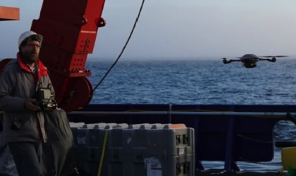 |
| Figure 1: InstantEye taking off from the fantail of the R/V Sikuliaq |
 |
| Figure 2: The author flying the InstantEye over a large ice flow in the Arctic Ocean |
The MQRUAS meteorological measurements were the first of their kind in any polar region, to our knowledge. Also this was the first time the author has flown an MQRUAS from a vessel at sea and from sea ice floes. Flying in such an extreme and different environment presented several challenges. One challenge was to obtain the required interim flight clearance (IFC) for operation from vessels at sea and flying in international air space, neither of which had been performed by NPS researchers with any type of UAS. This was obtained just before the start of the Sea State cruise, not in time to perform any at sea testing before the Sea State cruise. Other challenges were operating (1) in cold conditions, (2) in potentially icing conditions and (3) where the magnetic field is nearly vertical due to proximity to the magnetic North Pole. The latter challenge was crucial because the navigation and control of the InstantEye depends on accurate compass readings.
There were three goals to the MQRUAS measurements:
- Testing the feasibility of such measurements in Arctic Ocean conditions
- Quantifying the fine-scale atmospheric structure of the lower atmosphere
- Quantifying the amount of heat and moisture coming from leads (openings in the ice pack).
 |
Figure 3: Close up of the InstantEye,
with radiosonde instrument
package
attached underneath,
over ice in
the vicinity
of a lead (seen in the
background).
|
There were some operational issues encountered. During some of the flights over open water, ice crystals formed on the MQRUAS rotors. However, these did not appear to significantly affect performance and were easily cleaned off while changing batteries between flights. The cold conditions reduced the battery life from the usual 25-30 minutes to 12 - 15 minutes, at least as indicated by the control screen; we suspect the battery life was actually more than indicated. A more serious issue was compass performance. During three of the flights, the control screen indicated “Compass Error” and the MQRUAS became hard to control. In one case, when the MQRUAS was launched from the ship fantail, control became difficult and the author had to land on some thin ice alongside the ship. As the ship moved to recover the MQRUAS, it cracked the ice and the MQRUAS was pushed off into open water and sank before it could be rescued. (We had spares.) We believe the compass errors were a result of being so close to the magnetic North Pole, resulting in almost vertical magnetic force lines. Also the magnetic field generated by the ship may have caused distortions in the magnetic field.
Despite these issues, overall the experiment was a success. The meteorological data from the MQRUAS and fixed-wing UAS flights appeared to be accurate and we were able to quantify lead heat fluxes and also the fine scale-structure of the lower atmosphere and how it varies horizontally and temporally. These results are still being analyzed and will be published in a scientific journal article. Challenges remain, but the author believes that the MQRUAS shows great potential as a platform for scientific and operational meteorological measurements and he plans to continue testing the system in various marine environments including international waters off the coast of California in 2016 and in the seas surrounding Antarctica during a 2017 cruise.
Reprinted with permission from CRUSER News. All opinions expressed are those of the respective author or authors and do not represent the official policy or positions of the Naval Postgraduate School, the United States Navy, or any other government entity. The inclusion of these links does not represent an endorsement of the organization, service, or product.

Comments
Post a Comment