Posts

Showing posts with the label China

CATCH OF THE DAY: REFLECTIONS ON THE CHINESE SEIZURE OF A U.S. OCEAN GLIDER

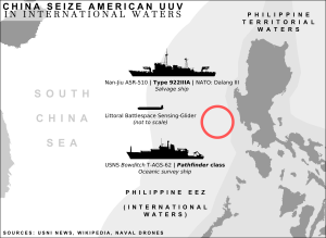
By Heiko Borchert On 15 December 2016, China seized an  Ocean Glider , an unmanned underwater vehicle (UUV), used by the U.S. Navy to conduct oceanographic tasks in international waters about 50-100 nautical miles  northwest of the Subic Bay port  on the Philippines. Available information suggests that the glider had been deployed from USNS  Bowditch  and was captured by Chinese sailors that came alongside the glider and grabbed it “despite the radioed protest from the  Bowditch  that it was U.S. property in international waters,” as the  Guardian  reported. The U.S. has “ called upon China  to return the UUV immediately.” On 17 December 2016 a  spokesman of the Chinese Defense Ministry  said China would return the UUV to the “United States in an appropriate manner.” Initial legal assessments by U.S. scholars like  James Kraska and Paul Pedrozo  suggest the capture is violating the law of the sea, as the unmanne...

CHINA SEIZES U.S. NAVY UNDERWATER DRONE

Image
On December 15th 2016, the Chinese Navy seized an American unmanned underwater vehicle (UUV) operating in international waters off the Western coast of the Philippines. The  USNS Bowditch ,  an unarmed T-AGS class hydro-graphic survey ship, was being shadowed by a People’s Liberation Army-Navy (PLAN) salvage vessel identified as a Dalang-III class (ASR-510). Graphic by: CIMSEC Member Louis MV The UUV had surfaced as part of a pre-programmed instruction, and sent  a radio signal marking it’s position for pick-up. As the Bowditch was preparing to recover the drone from the water, a small boat crew from the Dalang III raced in and plucked the unmanned vessel. The incident occurred approximately 50 nautical miles northwest of Subic, Luzon. While the exact type of drone is unknown, there have been several instances of U.S. Navy   Slocum Gliders   snagged in local fishermens’ nets or washed ashore on beaches in the Philippines. This type of drone is not weap...

Drones on the Frontlines of the South China Sea

Image
Chinese UAV imagery of Senkakus More than one war has started over the control of a group of isolated rocks in the middle of the ocean.  Tensions over disputed East China Sea islands called the Diaoyu by China and the Senkaku by Japan could someday precipitate skirmishes on or over the sea, if not a larger conflict.  It may very well possible that the first shots fired in any sort of combat over these islands will involve growing number of maritime unmanned aerial vehicles (UAVs) flying in the area.  Late in 2013, China established an  air defense zone  (ADIZ) over portions of the East China Sea.  Further south, near the disputed Spratlys, similar issues exists. To help enforce their claims over these areas, China is building a string of 11 drone bases along its coast by 2015. China has operated what is likely a variant of the S-100  rotary wing UAV off PLA(N) ships. China's Coast Guard, which is really the PRC's first line of defense ...

Evaluating China's Anti-Ship Drone Swarms

Image
The Project 2049 Institute recently released a report on People’s Republic of China UAV advances, with a focus on how those capabilities could be used to threaten U.S. Navy carrier strike groups.  China's expanding land and sea-based UAV inventory ranges from small tactical systems to medium-ranged Predator-class to UCAVs still under development.  This Anti-access/Area Denial capability, or A2/AD in naval parlance, represents just one of several layers of offensive systems the PLA is developing to exercise naval hegemony in the Western Pacific.    The report argues that "UAV systems may emerge as the critical enabler for PLA long range precision strike missions within a 3000 kilometer radius of Chinese shores."  This 3000 km radius represents an area well into the so-called Second Island Chain, control of which is commonly recognized as a long term strategic goal for the PLA. The report details Chinese strategists' plans t...

China's Expanding Maritime UAS Fleet

Image
 S-100 Camcopter on DCNS Landing Grid (DCNS Photo)   Unmanned systems have not been excluded from China's rapid naval expansion and modernization program.  Last month, China's State Oceanic Administration (SOA) announced it would establish a string of UAV surveillance and monitoring bases in provinces along China’s coastline by 2015.  The SOA will also use drones to increase surveillance of the disputed Diaoyu (Senkaku) Islands in the South China Sea.  In keeping with this announcement, China Maritime Surveillance (CMS), a law enforcement agency under control of SOA responsible for law enforcement within the PRC's territorial waters, exclusive economic zones (EEZ), and shores, awarded two contracts  this week to the French DCNS Group.  CMS will purchase landing grids for two planned CMS 1,500 ton off-shore patrol vessels to be delivered in 2013.  The DCNS landing grids allow helicopte...